
Township Significance Statement (Part 3)
SMITHFIELD TOWNSHIP (1876-1879)
REDFORD ROAD, BARRON, QUEENSLAND 4878.
Statement of Cultural Heritage Significance
© 2021 Phoenix
This statement of cultural significance was prepared by Dr Dave Phoenix in 2021 in accordance with the ICOMOS Burra Charter (1999) and the Queensland Department of Environment and Heritage Protection’s guidelines for assessing cultural heritage significance.
Part 3.
Description:
Physical Description:
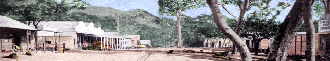
The former Smithfield township site is a 13-hectare (32-acre) rectangle of land at the end of Redford Road. It borders the northern bank of the Barron River, where there has been considerable erosion since 1876. The Esplanade, which used to be between 30 and 40 metres wide, has now eroded away. Several of the original streets have dirt tracks on them, but there is no evidence of the original buildings or any visible references to the original township.
The township was abandoned in 1879. In 1923 the Department of Lands issued Special Leases over parts of the township to allow the cultivation of sugar cane. The 80 freehold town allotments still exist and the individual titles are held by Pioneer North Queensland Pty. Ltd. The site is still used for growing cane and is sub-leased by PNQ to Ross Marino. However the area is approved for resource extraction and PNQ have a Queensland Environmental Protection Agency ERA (Environmental Relevant Activity for a resource activity) and a Development Permit for the site and at some stage in the future it will be used for sand extraction as part of their Barron Sands Quarry.
Governance:
The Smithfield township site was under the governance of:
- Cairns Road Board (1876-10 November 1879)
- Cairns Divisional Board - Division 1 (11 November 1879-19 December 1890) Cairns Divisional Board formed under Divisional Boards Act 1879.
- Barron Divisional Board (20 December 1890-30 March 1903)
- Barron Shire Council (31 March 1903-19 December 1919) (Barron Shire formed under Local Authorities Act 1902)
- Cairns Shire Council (20 December 1919-1940) (after the Barron Shire was abolished)
- Mulgrave Shire Council (1940-21 March 1995) (Cairns Shire was renamed Mulgrave Shire)
- Cairns City Council (22 March 1995-2008) (Mulgrave Shire was abolished and absorbed into the City of Cairns under Local Government (Cairns, Douglas, Mareeba and Mulgrave) Regulation 1994)
- Cairns Regional Council - Division 8 (2008- )
Planning schemes and previous cultural heritage assessments:
The first Mulgrave Shire planning scheme was adopted in 1975 for urban areas and 1978 for rural areas. This was superseded after amalgamation with Cairns City Council in 1995 by the Planning Scheme for the Balance of the City of Cairns (29 November 1996), the Cairns Plan 2005 (27 January 2005, amended 24 November 2005), the Cairns Plan 2009 (March 2009), the Cairns Plan 2016 v.1.0 (1 March 2016), the Cairns Plan 2016 v.1.1 (28 June 2018) and currently the Cairns Plan 2016 v.1.2 (11 December 2017).
The first heritage assessment in the Cairns area was carried out by the National Trust of Queensland in 1977. This study identified 54 places of cultural significance, mainly in the CBD. Smithfield was not one of the sites that was considered.
In 1992, Mulgrave Shire Council carried out a study of cultural heritage places which identified the Douglas Track as a significant place but did not mention Smithfield. Later that year, the Queensland Department of Environment and Heritage recognised the need for local area heritage studies and identified Cairns as an area of priority. Both Cairns City Council and Mulgrave Shire Council commissioned heritage studies.
In 1995 Cairns City Council and Mulgrave Shire Council were amalgamated to become Cairns City Council. The Mulgrave Shire Heritage Study, which was published in 1996 after amalgamation, recommended that Cairns City Council establish a heritage register of significant places, and identified Smithfield as one of 101 places in the old Mulgrave Shire area that were “places of potential historical cultural significance”.
Cairns City Council drafted a heritage strategy, which was published in their 1996 Planning Scheme for the Balance of the City of Cairns:
- 6.9.1. Heritage Objective 1.
To identify places of cultural and natural heritage significance in the Plan Area. - 6.9.2. Heritage Objective 2.
To provide the opportunity for heritage values to be taken into account when assessing proposals for development.
In 1997 Cairns Regional Council produced a Council Heritage Register of cultural heritage resources by combining the Cairns City Heritage Study and Mulgrave Shire Heritage Study. This was updated by Anne Meiklejohn in 1998.
In 1999 Cairns Regional Council drafted a cultural heritage strategy. In the first draft of the Cairns Plan (2005) the Council recognised Smithfield Cemetery and Old Smithfield Townsite as significant places of Non-Indigenous Cultural Heritage:
- 3.7.3. Schedule of Heritage Sites
Current Name: Redford Road, Smithfield
Other Known Name: Old Smithfield Townsite
Address: Redford Rd, Smithfield
History: The original Smithfield settlement developed on the banks of the Barron River in about 1877. It was finally abandoned following heavy floods.
Physical Description: Currently forms part of a cane farm
Physical Integrity: Fair. Predominantly of archaeological and social value although not readily accessible to the public. Upper levels have been disturbed by ploughing and flooding.
Statement of Significance: The settlement was one of the earliest satellite settlements around Cairns and particularly important for teamsters plying between the coastal port of Cairns and its raison d’etre, the Hodgkinson Goldfield.
In 2007, the Queensland Government amended the Queensland Heritage Act (1992) requiring local governments to establish a register of significant local cultural heritage places. Cairns Regional Council partnered with the Cultural Heritage Branch of the Queensland Environmental Protection Agency, and in 2008, they commissioned Environmental Resources Management Pty. Ltd. to undertake a comprehensive study of the region.
In 2011 the Council commissioned a thematic history and considered 240 submissions for places to be listed on the Local Heritage Register. Submission 86 was ‘Old Smithfield Township’ (DM5, No. 3415203). PNQ Pty. Ltd., the owner of the freehold title to the township objected to the listing on the grounds that they “need to traverse across the Township area to access the sand resource”. They argued that:
- A heritage boundary with a 10-metre buffer of the township site will effectively exclude the ability to traverse the land for access and will result in the sterilisation of half the available sand resource. Need the Township are not to be ‘locked up’. [PNQ] may need to find a new site or cause the operation to close. Area is also under sugar cane cultivation. Heritage Boundary will prevent the farmer to grow cane on this area and will make the whole parcel unviable.
The CRC Heritage Officer noted that:
- The place is currently identified as a Local Heritage Site in the Cairns Plan. The heritage listing will not restrict access to traverse over the site or the continued cultivation of sugar cane. The viability of the site will remain unchanged.
It was recommended that Cairns Regional Council proceed with the entry and the Old Smithfield Township site was entered into the Council’s Local Heritage Register.
PNQ Pty. Ltd. have a Queensland Environmental Protection Agency ERA (Environmental Relevant Activity for a resource activity) and a Development Permit for the site, but they have not yet applied to remove sand from the site and heritage considerations will only be triggered when development is proposed for the site.
Recently, several hundred artefacts have been uncovered by an amateur enthusiast, which suggest that the site still has considerable archaeological potential. In 2019 a PhD candidate at James Cook University commenced an archaeological survey of the township site and has located several thousand surface finds.
Go to ⇒ Part 4.