
Township Significance Statement (Part 1)
SMITHFIELD TOWNSHIP (1876-1879)
REDFORD ROAD, BARRON, QUEENSLAND 4878.
Statement of Cultural Heritage Significance
© 2021 Phoenix
This statement of cultural significance was prepared by Dr Dave Phoenix in 2021 in accordance with the ICOMOS Burra Charter (1999) and the Queensland Department of Environment and Heritage Protection’s guidelines for assessing cultural heritage significance.
Part 1:
Description of Place:
Smithfield township:
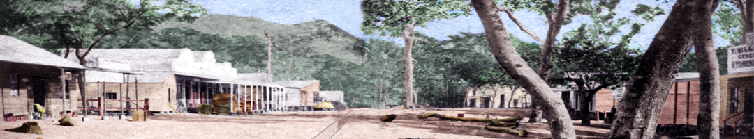
Smithfield was an ephemeral European settlement on the Barron River near Cairns. It served as a river port during the early European history of Cairns and the Hodgkinson gold field.
The township was established in late 1876, just a few weeks after the port of Cairns was declared. The township rivalled Cairns in importance for a while, with Cairns serving as a sea port for the Hodgkinson and Smithfield serving as a river port and supply centre for packers and their horse teams coming down the Douglas and Smith’s Tracks from the goldfield.
The establishment of Port Douglas and the Bump Track during 1878 diverted trade away from Smithfield and the township was abandoned in early 1879.
Place Details:
Place Name:
Redford Road, Smithfield.
Alternative Name:
Old Smithfield Township (1876-1879), Barron River, Queensland.
Listings QLD Place ID:
N/A (The site is not on the Queensland Heritage Register)
Place Location:
Place Name:
Redford Road, Barron, Queensland 4878.
Address:
Lots 101-120 & 201-220, Plan S199.1 (1 December 1876).
Lots 301-320 & 401-420, Plan S199.2 (8 March 1877).
Macdonald Street, Hill Street, Logan Street, Seymour Street, Norfolk Street and The Esplanade.
Coordinates:
16°51'45"S 145°42'04"E (GDA2020) – Plan S199.1
16°51'42"S 145°42'07"E (GDA2020) – Plan S199.2
Heritage Boundary:
From 16°51'34.78"S 145°42'3.85"E (GDA94) / UTM 361625.16mE 8135514.76mN (north-eastern corner at the intersection of Norfolk and Hill Streets), a straight line to 16°51'40.87"S 145°41'57.18"E / UTM 361429.06mE 8135326.28mN (north-western corner at the intersection of Hill and Logan Streets), a straight line to the northern bank of the Barron River at 16°51'51.80"S 145°42'7.94"E / UTM 361749.75mE 8134993.69mN (south-western-corner at the intersection of Logan Street and The Esplanade), then along the northern bank of the Barron River to 16°51'45.87"S 145°42'14.78"E / UTM 361924.78mE 8135160.04mN (south-eastern-corner of The Esplanade and Norfolk Street) and then a straight line back to the north-eastern-corner.
Area:
The total area of the site is 12.7 hectares (31½ acres).
Cultural Significance:
Criterion C:
The former Smithfield township site is of cultural significance at the local level. As the site of one of the earliest settlements in the Cairns area, it was established just a few weeks after Cairns was declared a port of entry at the end of 1876. The township thrived during 1877, and its population rivalled that of Cairns, however the establishment of Port Douglas in 1878 meant Smithfield subsequently failed and the township was abandoned in 1879.
The township site has the ability to reveal in an archaeological manner, information about life in the region during the establishment of European settlement in the late 1870s.
Although this area was later turned over to cane farming, it is still possible to recover archaeological evidence of settlement.
Archaeological Potential:
The Cairns Plan 2016 v1.2 notes:
Archaeological Potential: Possible High archaeological potential [at the Smithfield township site] but this needs to have some exploratory efforts to determine what values may still be attributable to the site. It may be that agricultural activities have destroyed evidence of the site but some further study and opening up would be required to determine what evidence remains.
Recent analysis of hundreds of artefacts uncovered at the township several decades ago, dates the artefacts to the 1870s. It is also alleged that there are many more artefacts still buried, which means further archaeological investigation is needed at the township site before mineral extraction and sand mining is allowed. Metal artefacts have been found at shallow depth scattered across the entire site, and lead, iron, brass, glass, stoneware and ceramic artefacts have been found buried at one specific location. These artefacts were recovered several decades ago from a depth which was sufficient to protect them from 75 years of cane farming practices.
The archaeological potential for the site is high and further investigation is warranted.
Go to ⇒ Part 2.
Map S199.1, Smithfield, 1876
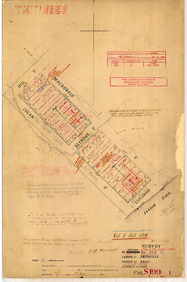
Survey of Sections Nos. 1 + 2 (Lots 1-20, & 201-220), Town of Smithfield, County of Nares, Land Administration District of Cairns, District of…
Map S199.2, Smithfield, 1877
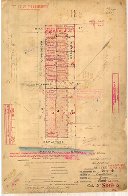
Survey of Sections Nos. 3 + 4 (Lots 301-320, & 401-420), Town of Smithfield, County of Nares, Land Administration District of Cairns, District of…