
Cemetery Significance Statement (Part 4)
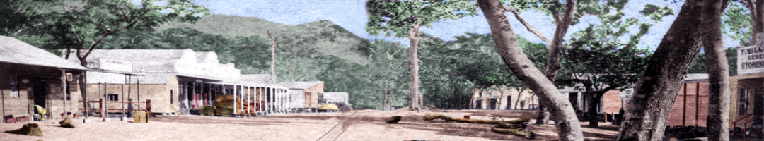
SMITHFIELD CEMETERY RESERVE (CEM.90 / R.76 / Por.46)
Stewarts Road, Barron, Queensland 4878.
Statement of Cultural Heritage Significance
© 2021 Phoenix
This statement of cultural significance was prepared by Dr Dave Phoenix in November 2020 in accordance with the ICOMOS Burra Charter (1999) and the Queensland Department of Environment and Heritage Protection’s guidelines for assessing cultural heritage significance
Part 4: Land Tenure.
- Go to ⇒ Part 1: Description
- Go to ⇒ Part 2: History
- Go to ⇒ Part 3: Graves
- Go to ⇒ Part 5: Governance
- Go to ⇒ Part 6: Burials
- Go to ⇒ Part 7: Images
Land tenure at Smithfield Cemetery, 1880-2020:
In 1880 the 100-acre riverside block, Portion 59, adjacent to the 5-acre Cemetery Reserve R.76, was leased by Donald Cameron who grew maize for several years. After a big flood in 1882 he defaulted on the lease, and in 1886 Por.59 became a 95-acre Camping Reserve.1
In 1893 the Camping Reserve was incorporated into the neighbouring Portion.57 and subdivided as Pors.57A, 57D and 57E. Por.57 was leased as a cane farm, firstly to Frederick Charles Coe under Special Lease SL.1334, then Francis King, and then in 1909 to Andrew Arthur Mason and Annie Wray Mason under SL.2890.2 In the 1920s, Thomas Robert John Blackman was added to the Mason’s lease.
Whether or not any of these farmers grew cane on the adjoining Cemetery Reserve R.76 is not clear, but agricultural activities may have taken place, as the boundary between the Cemetery Reserve and the Special Lease over Por.57E was unmarked, and the cemetery was indistinguishable from the surrounding paddocks apart from the blazed trees and few lone graves. The last burial at Smithfield Cemetery was in 1915.
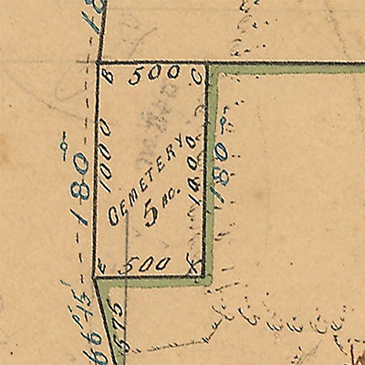
Survey of Cemetery (5 acres), Parish of Smithfield, surveyor F.H. Warner, 12 March 1878.
This is the Cemetery Reserve R.76 as laid out by Warner in 1878.
C8.88, Department of Natural Resources, Mines and Energy, Queensland Government.
By 1929 cane was being cultivated on part of the Cemetery Reserve. When Land Ranger Davenport 'Port' Bromfield from the Department of Lands inspected the area he found that Blackman had planted cane on three acres of the five-acre Reserve.3 Blackman claimed that the Mason’s had already cleared the three acres when he took over the lease, and that he had planted the first crop of cane there in January of that year. The other two acres at the Cemetery were in "a very dirty condition, being infested with Lantana and other weeds”. Bromfield identified “two or three graves on the northern portion of the Reserve” which were “sadly neglected and uncared for”.4
Bromfield noted there had not been any burials at the site "for the past 10 years, or more" (14 years in fact), and he did not consider that the cemetery was “likely to be required in the near future”, so the Cairns Land Commissioner, Chas. J.F. Miller recommended the Land Administration Board allow Blackman to grow cane there. Cairns Shire Council had no objections, and so at the end of 1929 a ten-year Informal Lease IL.1169 was issued. The lease allowed cane to be cultivated over 95% of the Cemetery Reserve, but the quarter-acre containing the graves at the northern end of the Reserve was to be left uncultivated.5
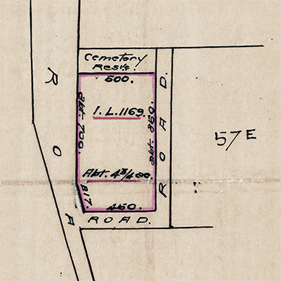
Plan showing Blackman’s Informal Lease IL.1169
which allowed cane to be grown over 4¾ acres of the 5-acre Cemetery Reserve from 1 January 1929.
Charles William Holland, secretary, Land Administration Board (29 October 1929), Reserve file R174, Department of Public Lands, Brisbane.
The land was resurveyed four years later by surveyor Norman Joseph Nielson. His 1933 plan shows that Blackman was only growing cane on about 70% of the Cemetery Reserve, but he had ignored the terms of the IL.1169 and cultivation encroached on the quarter-acre containing the graves.6 In addition, Blackman had constructed a cane barracks which was partly on the Reserve. The Land Administration Board, however, took no action on the matter.
In September 1937 Blackman’s cane farm was purchased by George Stewart, son of Smithfield cane farmer James Stewart who owned an adjoining lease and after whom Stewarts Road was named.7 In 1939 IL.1169 expired and, instead of applying to renewing the lease, Stewart asked for the Cemetery Reserve R.76 to be cancelled and a Special Lease issued over the whole five-acres. The Cairns Land Commissioner, Alexander Purdon wanted the Reserve inspected, but disruptions caused by WWII meant it was the end of 1942 before the Department of Health and Home Affairs took any action. When land ranger Thomas King visited the Cemetery in November 1942, he found that Stewart was already using “the whole of the Cemetery Reserve” for growing cane "with the exception of a small area around the graves”.8 King identified three graves, all of them in the forested northern section of the cemetery. The road reserve around the southern and eastern boundaries of the cemetery had also been illegally put under cane.9
Purdon wrote to the secretary of the Land Administration Board, John Lawrence Callaghan, advising him that “excepting an area of about two roods 16 perches (a little over half-an-acre), this Cemetery Reserve is not required”. The Board accepted his recommendation, and on 18 March 1943 the Reserve was divided into Por.46 and Por.47 - Por.46 being Cemetery Reserve R.76 which was reduced in size from 5 acres to 0.635 acres (2,570 m²).10 The remaining four-and-a-half-acres was renamed Portion.47 and was absorbed into Stewart’s cane farm on 1 April 1943 under the terms of a 20-year Special Lease SL.13196.11
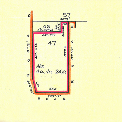
1943 Plan showing the divided 5-acre Cemetery.
Por.46 was the reduced ½-acre Cemetery Reserve CEM.90 with three graves discernible.
Por.47 was the remainder of the original cemetery which was leased to Stewart as a 20-year Special Lease SL.13196.
Special Lease SL.13196, (1 April 1943), Reserve file R174, Department of Public Lands, Brisbane.
Over the next few years, Stewart cleared the “thick forest” from the Cemetery Reserve, leaving just one palm tree growing close to the graves.12 By the end of the 1950s this palm tree had also disappeared and the cane barracks had been demolished.13
In March 1963, Stewart transferred Special Lease SL.13196 to his three sons, and shortly afterwards it expired.14 When Cairns land ranger, Keith William Reginald Perrett, inspected the area in August 1963 with a view to issuing a new lease, he found the Stewart brothers were cultivating cane across the whole of the Cemetery Reserve, “excepting an area about ten feet by six feet which carried a tall stand of spear grass”.15 George Stewart informed Perrett that the Cemetery Reserve “was unused and there was only one grave on it”.16 The Cairns Land Commissioner informed the Stewarts they were occupying the Reserve illegally and instructed them "to vacate the area and plough in the planted cane immediately". 17
On 12 November 1963 the Stewarts wrote to the Cairns District Land Office stating they had "vacated the land in question and have ploughed out the cane stools growing thereon". One of the Stewart brothers followed this up with a visit to the Cairns office a week later, where he met the Deputy Land Commissioner to explain once again that the Cemetery was unused and had only one grave. The Commissioner informed him that "irrespective of the number of graves on the area" they were required to vacate the entire Reserve. He also said that a new lease would only be issued for Por.47 when the Stewart brothers erected "a substantial fence" along the common boundary between Por.47 and the Cemetery Reserve.
Assistant land ranger Paul Kent Clay conducted a follow-up inspection of the Reserve in January 1964. He found the Stewart brothers had only cleared an area of about a third of an acre “from around the only supposed grave” and that “there was still an area to be ploughed out”.18 The Stewarts said they were unsure where the boundary of the Cemetery Reserve was, so Clay pointed it out to them. He recommended the Stewarts be allowed to harvest the offending cane at the end of the year then vacate the Reserve, but the Cairns Deputy Land Commissioner, who met with one of the Stewart brothers two months earlier and had discussed the matter with them, disagreed with Clay's recommendation, stating "I do not consider that the Stewarts were under a misapprehension as to the actual area [of the Cemetery Reserve]". He insisted they vacate the Reserve within one month or face prosecution under 'Section 372 Trespass, etc. (1910, s. 203)' of The Land Acts (Queensland 1962-1963).19 Clay noted that once the Reserve was vacated, "the area was never to be used again other than for its gazetted purpose [as a Cemetery]".
The cane was removed and Maxwell George Stewart phoned the Cairns District Land Office on 20 February 1964 to advise they had complied. The Department of Lands issued another 20-year Special Lease, SL.28844, over Por.47 adjacent to the Cemetery Reserve in October 1964. The Cemetery Reserve was redesignated from R.76 to CEM.90.
When the Department conducted their next inspection in December 1964, Perrett found that although some cane had been removed, the Stewarts still had cane growing over more than half of the Cemetery Reserve. Cairns Land Commissioner, John Alexander G. Goodwin, issued a third warning to remove the cane and vacate the Reserve. The Stewarts' protested that they were still not certain where the boundary of the Reserve was, so in June 1965, Mr. Bourke of the Cairns District Land Office met with them and “illustrated the boundaries of the Cemetery Reserve to the illegal occupier”.20 The Stewarts removed the cane, and when the Cairns Assistant Land Commissioner inspected the Reserve in August 1965, he was finally able to confirm that “all cane has now been removed from the area”.21
An inspection in May 1968 noted that a fence had not yet been constructed between the Reserve and Por.47, but the Cemetery area was “mown and in a tidy condition”. The Stewarts thought a fence on a cane farm would be "a very real nuisance", so the Cairns Land Commissioner, Austin Frederick Kimber, decided it would not be necessary as long as the Stewarts continued “to mow and maintain the cemetery in a clean and tidy condition”.22
The Mann family of Edmonton purchased Stewarts' farm in May 1971, and SL.28844 over Por.47 adjacent to the Cemetery Reserve was transferred as part of the sale. In November 1971 the Manns signed a Statutory Declaration agreeing "to mow and maintain the adjacent Cemetery Reserve in a clean and tidy condition".23 However this was not done, and once again the Reserve became overgrown and neglected. When members of the Historical Society of Cairns visited the cemetery in 1976, they found “rubble from a demolished building had been dumped around the grave sites” and other parts of the Reserve were overgrown with Allamanda vine. Society members pulled back the vine to expose the old wrought iron fence around the marked grave.24 When they pointed out that the farmer had encroached upon the Cemetery Reserve, Mr Mann “chided the Society”.25
The Society raised the matter with Mulgrave Shire Council, whom they believed to be the freehold owners of the Reserve, and they asked the Shire to restore the cemetery to its original condition. The Shire had no record of ownership and were unsure who owned the Reserve. When they discussed the matter at their next Council meeting, Councillor Wendel Hearl said it should be up to the Historical Society to maintain the cemetery, while Councillors Langtree and Robert Rossi recommended that the Shire take no action. Councillor Tom Pyne thought that as it was Cairns’ centenary year some steps should be taken to preserve the area.26
Mulgrave Shire referred the matter to the Cairns District Land Office who passed it on to the Land Administration Commission in Brisbane. They confirmed that Mulgrave Shire were the owners of the freehold title to Cemetery Reserve CEM.90, and the Mann family were trustees by statutory declaration "to mow and maintain the Cemetery Reserve in a clean and tidy condition".
Alan John Mann wrote to the Cairns Post explaining that he had purchased seventy cubic metres of building rubble for erosion control works on the northern bank of the Barron River and had only dumped it “around the lone grave on … the unmarked reserve” as a temporary measure as “access to the river was prohibited due to wet conditions”. He said he would shift the rubble at his earliest convenience. Mann accused the Society of "innuendo and speculation", and claimed, incorrectly, to have a Special Lease over the Cemetery Reserve. He did not explain why he had failed to maintain the Reserve as agreed in the Statutory Declaration.27
A year later the rubble was still there and Society president, Les Sim, took photographs of the neglected cemetery and forwarded them to the Cairns District Land Office asking that the matter be investigated. Assistant land agent Mr. S. Davis inspected the cemetery in September 1977 and confirmed that the Manns "have not been maintaining the Reserve in a mown state or in a tidy condition" and had, in fact, planted cane on more than half the Reserve and “a pile of concrete rubble had been dumped … and this covers the old grave”. The Manns were given one month to “have the cane removed and henceforth cease cultivation and also to remove the pile of concrete rubble without endangering or removing the mark proclaiming the old grave”.28
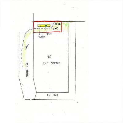
1977 Plan showing cane being grown on the Cemetery Reserve and rubble dumped around the graves.
'Memorandum' [Assistant Land Inspector S. Davis to the Land Commissioner, Cairns] (21 September 1977), Reserve file R174, Department of Public Lands, Brisbane.
The site was inspected in December 1977 and although most of the rubble had been removed, two large concrete slabs remained. The marked grave was now visible, but it was “overgrown and entangled with a burnt-out bush”. The Manns had removed the cane but had replaced it with a crop of cowpea. Davis reported "the condition of the Reserve ... was still unsatisfactory", so the Cairns Land Commissioner, Cyril Malcolm Buchanan, wrote to the Manns again, informing them that they had one month to "cease cultivation of the Cemetery Reserve ... remove the remaining concrete rubble ... and tidy the grave". Buchanan warned "you must realize that you are endangering ... your Lease ... because your undertaking is not being complied with".29
In January 1978 Land Inspector Norman Vincent Brooks inspected the Reserve and found that the concrete slabs had been removed and some of the cowpea, but parts of the Reserve were still under cultivation and the burnt-out bush was still entangled in the grave. Commissioner Buchanan wrote to the Manns for a third time, calling upon them "to maintain the whole of the Cemetery Reserve in a clean and tidy, mown condition". He warned that "a continued breach ... could lead to serious action being taken against your lease".30
The Reserve was inspected in May 1978, this time by Cadet Land Inspector Mark Peter Stallman, who found it to be in a satisfactory condition. He recommended that another inspection be carried out later in the year, but the records do not indicate whether the Department of Lands undertook this inspection.
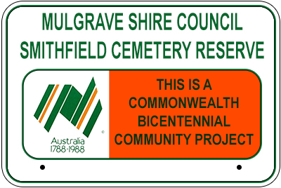
In 1985 SL.28844 over Por.47 expired and was replaced with SL.09/47008 valid for 30 years. This new lease included the earlier condition that the lessees fence two sides of the reserve within the next twelve months. However in 1986 Mulgrave Shire Council indicated they wanted to be trustees of the cemetery, whereupon they would erect a fence. Mulgrave Shire had been discussing the neglected cemetery at their council meetings and decided that because “no control was being exercised over the area” they should apply to be appointed as trustee. They planned to fence, restore, landscape and re-dedicate the cemetery as a Commonwealth Bicentennial Community Project.31
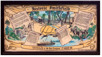
Mulgrave Shire were appointed trustees on 11 June 1987. The Shire erected a post and chain fence around the cemetery, with a wooden picket fence and gate along the western boundary facing Stewarts Road. They planted trees and palms and erected a timber picket fence around the marked grave. The cemetery was re-dedicated on 13 August 1988 by Mulgrave Shire mayor, Councillor Tom Pyne, and historian Clive Morton. An interpretive sign was unveiled containing information provided by Ben Crossland, grandson of Smithfield blacksmith, Edwin Crossland.

1990 aerial image of the Cemetery Reserve, showing young trees planted by Mulgrave Shire Council after they were appointed trustees.
Image QAP4681-Frame 082, (6 December 1990), QImagery, © State of Queensland 2020 under a Creative Commons Attribution 4.0 International (CC BY 4.0) licence.
In 1995 Mulgrave Shire amalgamated with the Cairns City Council, and by 2000 the cemetery was once again overgrown with Allamanda vine, which completely covered the marked grave. The vine was cut back in August 2000 and has since been eradicated.
In 2013 Cairns Regional Council commissioned 'Converge heritage + community' consultants of Brisbane for conservation advice for the cemetery. They recommended that “the cemetery reserve should be maintained as a simple and uncluttered space [and] interpretation should be kept to a minimum”. They also suggested that “further research to confirm the history and location of the site should be prioritized”.32 The Council has not yet commissioned this work (2018), but this significance statement compiled by Dr. Dave Phoenix goes a long way towards meeting that recommendation.
In 2015, Por.47 adjoining the cemetery was granted to the Mann family as freehold title. Cairns Regional Council currently holds freehold title to the Cemetery Reserve and is the trustee. They have identified the site as significant Non-Indigenous Cultural Heritage and placed it on the Local Heritage Register.
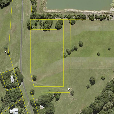
2020 aerial image of the Cemetery Reserve.
Cairns_2020_10cm_SISP_Urban (16 July 2020), Queensland Globe, © State of Queensland 2020.
Go to Cemetery Significance Statement ⇒ Part 5: Governance.
-
1. 'Survey of Portions 57 and Camping Reserve' [surveyor Thomas Behan] (12 May 1883), C157.314, Department of Natural Resources, Mines and Energy, Queensland Government. ↩
-
2. 'Sketch of Pors.57E, 57F, 57G and Cem.Res.76' [Lands Department ranger P. Bromfield] (July 1929), SL.2890, Reserve file R174, Department of Public Lands, Brisbane. ↩
-
3. Francis King was the son-in-law of William Walter Mason of Acacia Bank station on the northern bank of the Barron. Andrew Arthur Mason was Mason’s third son (1897, Queensland–?). ↩
-
4. 'Letter' [D. Bromfield, temporary Land Ranger, Cairns District, to Department of Public Lands, Brisbane], (dated Cairns, 29 July 1929), Reserve file R174, Department of Public Lands, Brisbane. ↩
-
5. 'Plan IL.1169' [Land Administration Board secretary C.W. Holland] (29 October 1929) Reserve file R174, Department of Public Lands, Brisbane. ↩
-
6. 'Plan of Portions No. 57A, 57D & 57E in the Parish of Smithfield' [surveyor Mr. N.J. Nielson] (6 May 1933), Reserve file R174, Department of Public Lands, Brisbane. ↩
-
7.James Stewart (1860, Ireland–1939, Cairns). ↩
-
8. 'Plan of Cemetery Reserve R.76' [land ranger Thomas King] (1 December 1942), Reserve File R.174, Department of Public Lands, Brisbane. ↩
-
9. 'Letter' [Land Administration Commission to Mulgrave Shire Council] (dated Brisbane, 15 July 1976), D2618, Cairns Historical Society. ↩
-
10. Queensland Government Gazette (29 March 1943): 905.
The Cemetery Reserve R.76 was reduced from five acres to 2 roods, 16 perches. ↩ -
11. Por.47, Special Lease SL.13196 (1943–1963) to George Stewart, followed by SL.28844 (1964–1984) to Maxwell George Stewart, Mervyn William Stewart and Bryan John Stewart.. ↩
-
12. Letter titled ‘Re: Cemetery Reserve R.76, parish of Smithfield’ [N.V. Brooks, Land Agent, District Land Office Cairns, to Les Sim, President, Historical Society of Cairns], (dated Cairns, 14 September 1977). ↩
-
13. Aerial photographs of the Smithfield area: Film QAP298, 30 June 1952; Film ADA544, 1 August 1952; Film QAP73, 1 November 1957; Film QAP993, 16 November 1959; Film QAP1656, 1 October 1965, QImagery, © Queensland Government. ↩
-
14. Special Lease SL.13196 (1943–1963) granted to George Stewart was transferred to Maxwell George Stewart, Mervyn William Stewart and Bryan John Stewart on 30 March 1963. ↩
-
15. Letter titled ‘Re: Cemetery Reserve R.76, parish of Smithfield’ [N.V. Brooks, Land Agent, District Land Office Cairns, to Les Sim, President, Historical Society of Cairns], (dated Cairns, 14 September 1977). ↩
-
16. 'Inspection Report' [Cairns Land Ranger Perrett] (22 August 1963), Reserve file R174, Department of Public Lands, Brisbane. ↩
-
17. 'Memo' [Land Commissioner to the District Land Office, Cairns] (dated 6 September 1963), Reserve file R174, Department of Public Lands, Brisbane. ↩
-
18. 'Inspection Report' [Cairns Land Ranger P.K. Clay] (24 January 1964), Reserve file R174, Department of Public Lands, Brisbane. ↩
-
19. 'Letter' [Land Commissioner, Cairns to M.G., M.W. & B.J. Stewart] (dated 11 December 1964), Reserve file R174, Department of Public Lands, Brisbane. ↩
-
20. 'Memo' [Land Commissioner] (dated Cairns, 15 June 1965), Reserve file R174, Department of Public Lands, Brisbane. ↩
-
21. 'Letter' [Assistant Land Commissioner to Land Commissioner] (dated Cairns, 10 September 1965), Reserve file R174, Department of Public Lands, Brisbane. ↩
-
22. 'Letter' [Land Commissioner, Cairns to M.G., M.W. & B.J. Stewart] (dated 29 May 1968), Reserve file R174, Department of Public Lands, Brisbane. ↩
-
23. 'Statutory Declaration' (signed by M.B. Mann, John Mann & Geoffrey G. Mann and dated 22 November 1971), Reserve file R174, Department of Public Lands, Brisbane. ↩
-
24. W.T. 'Bill' Johnston, President of the Historical Society of Cairns, Memo dated January 1992, D2856, Cairns Historical Society. ↩
-
25. Alan John Mann, 'Cemetery Safe', Cairns Post, 22 May 1976. ↩
-
26. 'Letters' [Mulgrave Shire Council to the Land Administration Commission] (dated 19 May 1976; 16 July 1976), D2618, Cairns Historical Society. ↩
-
27. Alan John Mann, 'Cemetery Safe', Cairns Post, 22 May 1976. ↩
-
28. 'Letter' [Land Commissioner C.M. Buchanan to the Mann family] (dated Cairns, 26 September 1977), D2618, Cairns Historical Society. ↩
-
29. 'Letter' [Land Commissioner C.M. Buchanan to the Mann family] (dated Cairns, 8 December 1977), Reserve file R174, Department of Public Lands, Brisbane.. ↩
-
30. 'Letter' [Land Commissioner C.M. Buchanan to the Mann family] (dated Cairns, 27 January 1978), Reserve file R174, Department of Public Lands, Brisbane.. ↩
-
31. Queensland Government Gazette (11 June 1987). ↩
-
32. Benjamin Gall, Converge heritage + community, Brisbane, 'Report to Cairns Regional Council, Old Smithfield Cemetery: Conservation Advice', (August 2013). ↩