
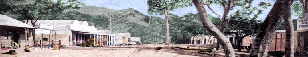
The Packer's Camp at Kurra: pulay-Kamerunga (1876)
In October 1876 the first packers and their horse teams came down from the Hodgkinson to Trinity Bay to load up with stores and supplies. They were not impressed with the condition of either Smith's Track or Douglas' Track, but it was the poor state of the road from the Barron into Cairns that was of most concern. The last 10 miles into Trinity Bay was a tough slog around Mount Whitfield, across the tidal mudflats at Saltwater Creek, and then through bogs and deep sand. When the packers arrived at the new port of Cairns they found mangroves, tea-tree swamps, brackish, stagnant water, and no feed for their exhausted animals.
The open forest country at the foot of the range, however, offered good grazing land and there was plenty of fresh water in Bana Bidagarra (the Barron River) at the place the Yirrgandji people called Kurra: pulay (Kamerunga). If steamers with a shallow-draft could run up the Barron and discharge their cargo at the limit of tidal water, the packers could camp on the river at the foot of the range, and would not need to make the arduous journey into Cairns.
The packers make a camp at the Barron River
David Spence, Acting-Sub-Collector of Customs, arrived at Trinity Bay from Cardwell on 6 October 1876. He selected the site for the new port of Cairns and then went to inspect Smith’s Track and Douglas’ Track. He thought the open forest country at the foot of the range by the Barron would be a good site for a river port and packer’s town, but he had concerns that the bar at the mouth of the river would be too shallow and an impediment to river traffic.1 On 16 October 1876, Spence set off with Captain Brittain in the pilot’s cutter to sound the river. Spence wrote to William Thornton, Collector of Customs in Brisbane2
I have examined and sounded the Barron River, and, were it not for the bar (on which I found only three feet low water springs) and the exposed anchorage, it would be an excellent site for a township. Sounding for a distance of four miles, I found nothing less than two-and-a-half fathoms, low springs; and I am informed by Mr. Ingham, of the steamer Louisa, that he found two fathoms for a distance of nine miles having taken his small steamer that distance, leaving only about one mile to the foot of the range, with open forest country and high banks to the river.3
Spence had no doubt that a packers’ town would be formed at the head of navigation on the Barron.4
The Engineer of Roads for the Northern Division, Archibald Campbell Macmillan of Bowen, and Road Works Overseer, Charles Hugh Macdonald, arrived at Trinity Bay with a road construction crew a couple of days later. They set off to begin work improving the steeper sections of the Douglas Track before the onset of the wet season. Macmillan found the banks of the Barron very thick and scrubby, but four miles from the bottom of the range, on the southern bank, he found open country large enough for their construction camp.5
While some people cleared land and began erecting buildings in Cairns, others decided to set up camp at the Barron. A makeshift packers’ camp sprang up at the river crossing near the point where Smith’s and Douglas’ Tracks met at the foot of the range. It was reported that several persons had gone there from Cairns with the view of establishing shanties. Old Bill Smith packed up his camp at Smith’s Landing on the Inlet in Cairns, and set up a bush pub and store by the Barron. The packers’ camp grew to around 30 or 40 dwellings and soon became known as ‘Smith’s Camp’.6

Barron River crossing at Kamerunga, Glacier Rock and Red Bluff in the distance.
Image number: 1227, Queensland State Archives.
Smith's Camp on the Barron River at Kamerunga
Surveyors Warner and Sharkey, Spence, Captain Brittain, and Captain Davies of the S.S. Porpoise set off from Cairns on the evening of 9 November 1876 to inspect Smith’s camp, “the embryo settlement at the head of the Barron”, which was about eight miles from the mouth of the river, 12 miles from Cairns by water, and scarcely more than a mile from the foot of the range where Douglas’ Track descended.7 A visitor from southern Queensland recalled:
We reached our destination called the head of navigation [on the Barron]. Here there is the nucleus of a township consisting of a store, blacksmith’s shop, a grog shanty (of course), and some Packers’ Camps. It is from here that packers load to go over the range (only one mile distant) to the Hodgkinson, as the road to Cairns is dreadfully bad through scrubs and mangrove swamps.8
It was noted that:
No permanent site for a town has yet been determined upon [here at the Barron], however, nor has any survey been made; but as somewhere in the neighbourhood will ultimately be the main camping places for packers and teamsters, and goods will be conveyed up the river from the port by such steamers as the P.S. Louisa, the time will come … when a busy thriving township will spring into existence here. The Louisa can take up 15 tons without difficulty, so that the heaviest machinery can be trans-shipped into her at this port and conveyed by her to within a mile of the range.9
Smith's Camp was near the crossing place on the Barron, on a piece of forest ground about 12 to 18 acres in size. Police Magistrate Howard St. George estimated the joint population at Cairns and the Barron River was around 150 people, but it seemed there were now more people on the Barron than there were in Cairns.10 The papers reported:
A regular stampede – principally of the smaller fry, however – has taken place during the last day or two from this town [Cairns], to a locality some four miles up the Barron River, where it is believed a new township will be formed.11
When Government Staff Surveyor John Phillip Sharkey visited Kamerunga and inspected Smith’s Camp on 9 November 1876, he found locals were keen to see a new township laid out, but there were different opinions as to the best position for the settlement. Having just spent the last five weeks pegging out more than 200 allotments in eight sections along Trouton Esplanade in Cairns, Sharkey could see little benefit in establishing another township a few miles away.12 He considered his work at Trinity Bay was finished, and on 19 November 1876 he boarded the S.S. Florence Irving and sailed for Brisbane.13 The future of the Barron River settlement looked uncertain.
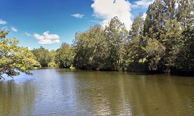
Barron River crossing at Kamerunga.
| Go to the next section ⇒ Establishing Smithfield Township. | |
 |
This webpage is an excerpt from the upcoming book Old Smithfield: Barron River township (1876-1879) by Dr Dave Phoenix. Find Out More Here |
Featured Artefacts from Old Smithfield:

-
1. Capricornian (Rockhampton), 21 October 1876: 685. ↩
-
2. William Thornton (1817–1884). ↩
-
3. The Week (Brisbane), 4 November 1876: 20-21. ↩
-
4. Ibid. See also: The Week (Brisbane), 28 October 1876: 6. ↩
-
5. The Week (Brisbane), 4 November 1876: 20-21. ↩
-
6.Mackay Mercury and South Kennedy Advertiser, 25 November 1876: 2; Queenslander, 25 November 1876: 1. ↩
-
7.Some historians claim that Frederick Warner found this track first, but Warner only travelled along the Douglas Track and did not discover a track of his own. There are reports which refer to ‘Warner’s Track’, but this is in fact the Douglas Track. ↩
-
8.Warwick Examiner and Times, 2 December 1876: 2. ↩
-
9.Rockhampton Bulletin, 24 November 1876: 2. ↩
-
10. Daily Northern Argus (Rockhampton), 24 November 1876: 2. ↩
-
11.Capricornian (Rockhampton), 25 November 1876: 754, reprinting an article from the Cooktown Courier, 16 November 1876. ↩
-
12. Surveyor John Phillip Sharkey, Plan of sections no. 1 to 30, township of Cairns, district of Cook, 1877, Accession number 85-2-5, Bib 695688, Record number 150383, John Oxley Library, State Library of Queensland; Brisbane Courier, 21 November 1876: 2. ↩
-
13. Brisbane Courier, 2 December 1876: 5. ↩